

Scientist of the Day - Pontcysyllte Aqueduct

An aerial view of Pontcysyllte Aqueduct, with the River Dee beneath, traversed by the Ellesmere (now Llangollen) Canal, modern photo (Wikimedia commons)
The Pontcysyllte Aqueduct, carrying the Ellesmere Canal over the River Dee in northeastern Wales, opened to its first canal boat on Nov. 26, 1805. The canal was designed and built by Thomas Telford and William Jessop. Telford is the bigger name now – the “Father of Civil Engineering” – but at the time, Jessop was the more experienced canal builder and Telford was fresh out of the gate. However, Telford pretty much took over this project and established himself with this one aqueduct as a civil engineering force to be reckoned with.

Distant view of the Pontcysyllte Aqueduct, recent photo by Michael Garlick (Wikimedia commons)
The Pontcysyllte Aqueduct (pronounced “pont-ker-suth-tee”) was intended to be part of an inland waterway called the Ellesmere Canal that connected the River Severn at Shrewsbury to the River Mersey at Liverpool. The Ellesmere Canal was never finished, as the financing dried up, so it never reached either Liverpool or Shrewsbury, and eventually its parts were incorporated into other canal systems, such as the Chester Canal. Bu a section in the middle, where the River Dee comes in from Wales on its way to the north, was completed, and this stretch included the marvelous Pontcysyllte Aqueduct.
The Pontcysyllte Aqueduct is built on stone piers that rise 116 feet above the river valley; the piers support a 1000-foot-long iron trough, cast in 52-foot sections, which carries the canal water, a footpath, and the narrowboats themselves. The trough rests on arched iron ribs, which in turn sit on the 19 piers; the resulting structure is surprisingly light and elegant.

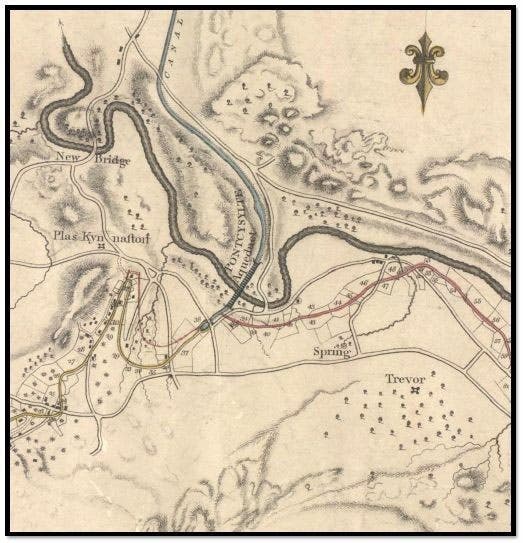
Map of the Pontcysyllte Aqueduct crossing the River Dee in Denbighshire, Wales, by William Jessop, 1803; the River Dee loops across horizontally, and the aqueduct is at center, running from SSW to NNE (plaskynastoncanalgroup.org)
Last year we wrote a post on Telford that focused on the Pontcysyllte Aqueduct, and which included two long-distance shots of the stone piers riding out of the River Dee valley, one terrific photo of a longboat passing through the aqueduct, and a map made by Jessop in 1803 of the area containing the aqueduct. Today we show 3 different photos, and repeat only the map, which is unique.
The Ellesmere Canal is now known as the Llangollen Canal, and in 2009, the Pontcysyllte Aqueduct and a stretch of the Ellesmere Canal were designated a World Heritage Site (no. 1303). The WHS webpage for the aqueduct has an array of photos that you will not find elsewhere (although they are not really as nice as the ones available on Wikimedia commons). As you can see, canal waterways are not very wide, just slightly over 7 feet across, so a canal boat must have a beam of 7 feet or less, which is why, one might suppose, they are called narrowboats. A narrowboat can be any length, but if it is 56 feet long or less, it can pass through any canal and any set of locks on what used to be called the British Waterways system.

Eye-level view of a narrowboat crossing the Pontcysyllte Aqueduct, modern photo (Wikimedia commons)
Most of the smaller canals, like this one, are now used exclusively for recreational tourism. In 2012, the 2400 miles of canals that made up the British Waterways, a government body, were transferred to the Canal & River Trust, a charitable organization. Not being a Brit, I don’t know what difference this transfer has made to the canal tourist industry and the task of preserving historic canals. I hope it means that engineering treasures like the Pontcysyllte Aqueduct will have a better chance of surviving.
The Canal & River Trust website has an entry on the Pontcysyllte Aqueduct, and it includes a 2-minute video, which I link to separately here. Be forewarned, it might be queasy watching for those of you who are heights-sensitive, as I am, primarily because, as you will quickly notice, there is no railing at all on one side of the aqueduct. It doesn’t seem to bother the narrowboat owners who are making the crossing.

Pontcysyllte Aqueduct, River Dee, northeastern Wales, designed and built by Thomas Telford, 19th-century engraving (Wikimedia commons)
If the aqueduct looks at all familiar to you and you don't know why, it is possible that you are recalling our April Fool’s post of 2020 on Eleazar Root, which opened with a contemporary engraving of the Pontcysyllte Aqueduct (fifth image here), the leaking joints of which Root supposedly fixed with his Root Canal Sealant. Ah, the good times we had as we entered the COVID era.
William B. Ashworth, Jr., Consultant for the History of Science, Linda Hall Library and Associate Professor emeritus, Department of History, University of Missouri-Kansas City. Comments or corrections are welcome; please direct to ashworthw@umkc.edu.


