Scientist of the Day - Ptolemy of Alexandria

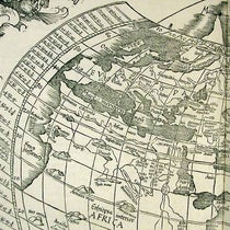
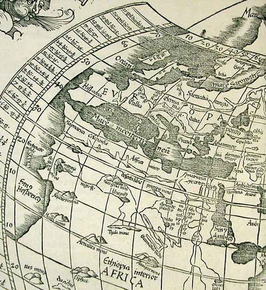
The Mediterranean region, detail of world map, woodcut, Geographicae enarrationis libri octo, by Ptolemy of Alexandria, 1525 (Linda Hall Library)
Ptolemy of Alexandria, sometimes called Claudius Ptolemy, lived in the first half of the second century CE. He was Greek, but unrelated to the Ptolemaic line of pharaohs who ruled Egypt until the death of Cleopatra.

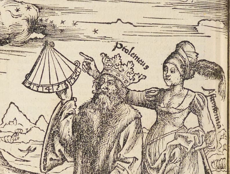
Attempted portrait of Ptolemy of Alexandria, detail of woodcut in Margarita philosophica, by Gregor Reisch, 1517 (Linda Hall Library)
Ptolemy is best known as an astronomer, author of the Almagest, which provided geocentric models for the seven known planets and a star catalog. It was everyone's go-to guide to the heavens until Copernicus, and for about a century after that. We wrote a post on Ptolemy and the Almagest just last year.
Ptolemy, however, was also a cartographer, one of the greatest cartographers in history, and author of the most accomplished book on the subject to come out of the ancient world. It is remarkable that he was the undisputed master of two separate disciplines (although astronomy and cartography are both mathematical subjects). It is also remarkable, now that I think about it, that I learned all about Ptolemaic astronomy in graduate school, and heard not one word about his contributions to the science of mapping.

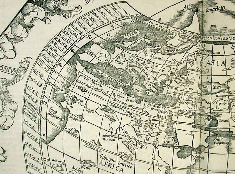
World map, woodcut, Geographicae enarrationis libri octo, by Ptolemy of Alexandria, 1525 (Linda Hall Library)
Ptolemy's book on the subject is called Geographia, because it included instructions and data for mapping the Earth, and, we think, a map of the entire inhabited region of the Earth (the oikumene) and 26 regional maps. There survive manuscript copies of the Geographia with maps, although they are certainly not original. But they were easily re-constructed, because Ptolemy not only provided several mathematical systems for making a proper map – called projections – but he also provided some 8,000 data points – the longitude and latitude of 8,000 cities, towns, mountains, lakes, gulfs, oases, whatever could be pinpointed with some accuracy. With one of his projections, and his list of known locations, it was easy enough to make many maps.

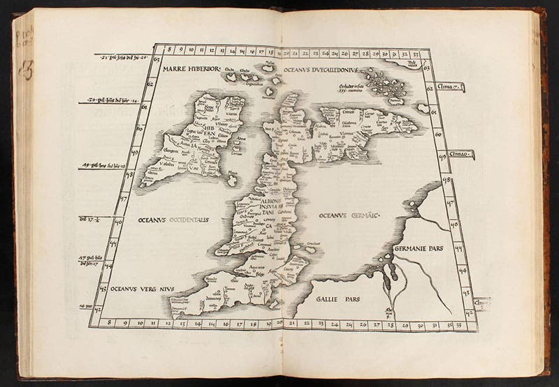
Britannia, regional map, Europe I, woodcut, Geographicae enarrationis libri octo, by Ptolemy of Alexandria, 1525 (Linda Hall Library)
The hard part was determining the longitude and latitude of so many locations, especially those in Asia or Libya (Ptolemy's name for Africa). Here Ptolemy had help. A predecessor named Marinus of Tyre had compiled a large gazetteer of the locations of named places, and Ptolemy used Marinus's list as the basis of his own. Marinus had prepared his catalog of cities and towns mostly from traders' and travelers' estimates of how long it took to get from place to place. A caravan could cover about 170 stadia a day. A stade or stadium, the basic unit of distance in the ancient world, was around an eighth of a mile. Distances across water were estimated from sailing times.
Marinus’ and Ptolemy’s determinations of longitudes and latitudes for Europe were accurate enough (although both geographers had the Mediterranean extend much too far), but the positions for Asian and African cities and trading centers were often inaccurate, especially since travel narratives differed widely in their estimates.

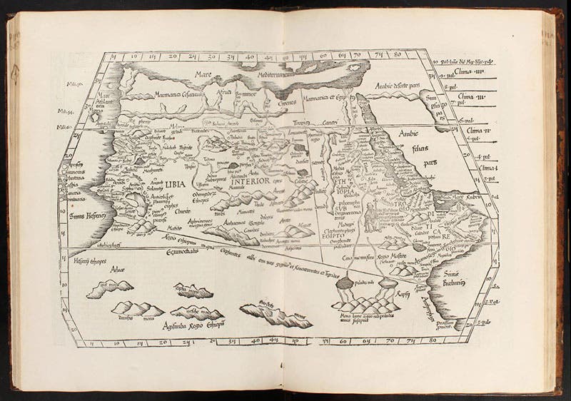
Northern Africa, regional map, Africa IV, woodcut, Geographicae enarrationis libri octo, by Ptolemy of Alexandria, 1525 (Linda Hall Library)
Still, Ptolemy’s world map (third and ninth images) is recognizable, especially the Mediterranean section, north of the Tropic of Cancer (first image). The southern part of Africa was then unexplored, and there were no known human habitations west of the Azores (Ptolemy’s meridian of 0º longitude) or east of China (180º for Ptolemy, a considerable over-estimate), and Ptolemy thought the Indian Ocean was closed in by a southern land mass. But no European knew any better when Ptolemy’s Geography was first printed in 1478.

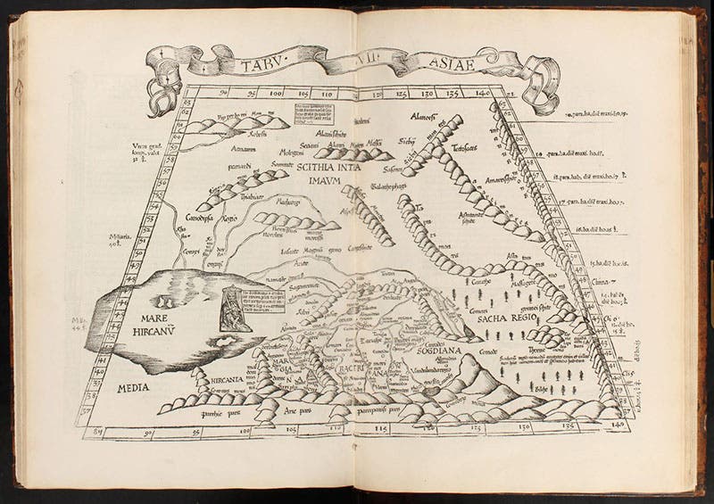
Central Asia, regional map, Asia VII, woodcut, Geographicae enarrationis libri octo, by Ptolemy of Alexandria, 1525 (Linda Hall Library)
There were several incunable editions (printed before 1501) of the Geographia, most with woodcut maps copied from manuscript editions, although the 1478 edition – amazingly – had engraved copperplate maps. Most of these were hand-colored, and all were magnificent, but we have no incunable edition in our collections. Our earliest edition was printed in 1525, and we have another of 1540. By that time, it was realized that there was a lot more to the Earth than Ptolemy had mapped, and that many of his distances and locations were in error. So most 16th-century editions of Ptolemy’s Geography – like our two – include Ptolemy’s 27 original maps, and then at least 27 new maps, correcting Ptolemy and adding in southern Africa and the New World, and, after 1530, the discoveries of Magellan. Since this is a post on Ptolemy, we show only Ptolemaic maps here.

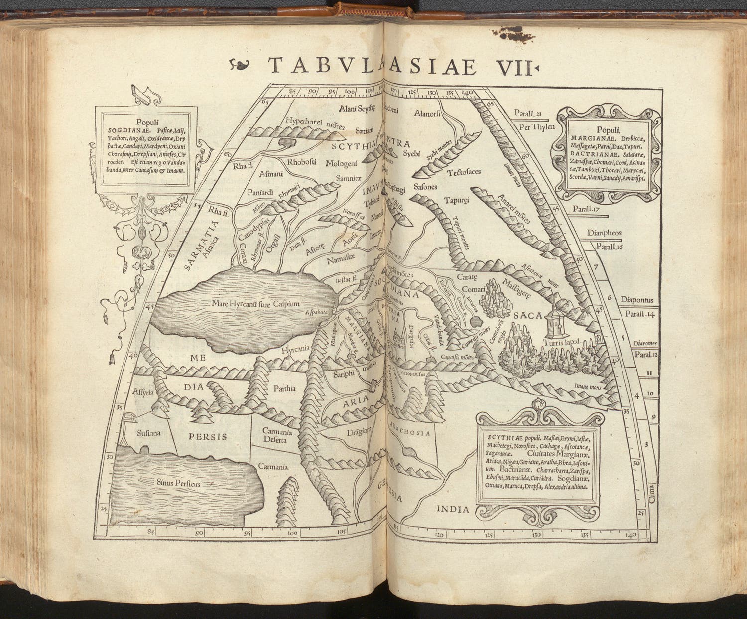
Central Asia, regional map, Asia VII, woodcut, Geographia vniversalis: vetus et nova, by Ptolemy of Alexandria and Sebastian Münster, 1540 (Linda Hall Library)
Ptolemy’s reconstruction of the world continues to generate original scholarly inquiry, nearly 2000 years later. One source of Asian locations was the caravan route along what is now called the Silk Road that ran east from the Mediterranean along latitude line 36º N into Central Asia. The first leg ended at a place called Turris lapidea – the Stone Tower. It was mentioned or depicted on Asia map VII. This was a major stopping point, a halfway house on the Silk Road, and yet no one could figure out what it referred to – a natural rock formation, a building, or something else. After centuries of speculation, a book recently appeared that claimed to have solved the problem. It is called, in the U. S. edition, Mapping the Silk Road: The Riddle of Ptolemy's Stone Tower (2022), by Riaz Dean, and is, I must say, a readable introduction to the Silk Road and Ptolemy's Geography, while also providing the author's attempt at identifying the Stone Tower, a story we will not spoil here. For a more scholarly introduction to the Geography, I recommend Ptolemy's Geography: An Annotated Translation of the Theoretical Chapters (2000), by J. Lennart Berggren and Alexander Jones, which has a center plate section showing in color some of the medieval manuscript and incunable Ptolemaic maps that we do not have.

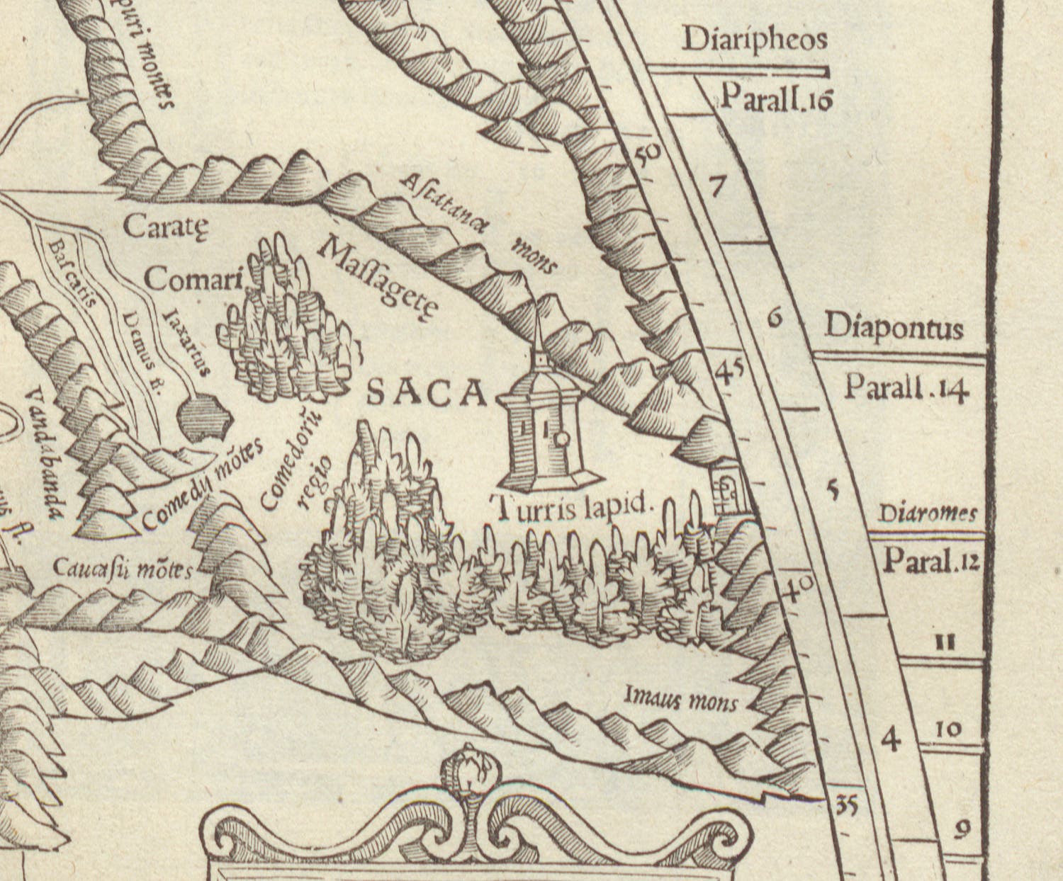
The Stone Tower, Turris lapidea, detail of regional map, Asia VII, woodcut, Geographia vniversalis: vetus et nova, by Ptolemy of Alexandria and Sebastian Münster, 1540 (Linda Hall Library)
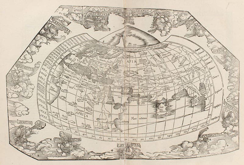
Our 1525 Geography, Asia map VII (sixth image), mentions the Stone Tower but does not show it. So we include Asia map VII from our 1540 edition (seventh image), and a detail of right center, where you can see a picture of the Stone Tower (eighth image). We also include the 1540 version of Ptolemy’s world map (last image).
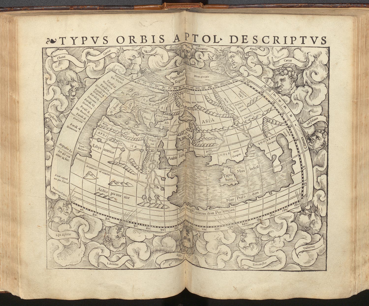
World map according to Ptolemy, woodcut, Geographia vniversalis: vetus et nova, by Ptolemy of Alexandria and Sebastian Münster, 1540 (Linda Hall Library)
We have no real portrait of Ptolemy, but Renaissance printers commissioned a few, most of which we showed in our first post on Ptolemy, including a woodcut of 1517 in the Pearl of Philosophy by Gregor Reisch. Here we show a detail of that woodcut (second image). The crown on Ptolemy's head reflects continued confusion with the Ptolemaic rulers of Egypt.
William B. Ashworth, Jr., Consultant for the History of Science, Linda Hall Library and Associate Professor emeritus, Department of History, University of Missouri-Kansas City. Comments or corrections are welcome; please direct to ashworthw@umkc.edu.